Tour Day 4: Moab, UT to Moab, UT

April 30th, 2009

26.47mi / 2:08:48 time / 12.3 mph avg. / 38.0 mph max. / 1442 ft. climbing / 11 mi hiking
Staying at Best Western, Moab

The original plan for this day was to leave the Arches campground in the morning, ride over a couple big hills and 18 miles before we even left the park, drop down to 4000 feet at the Colorado, and climb back up to 7200 ft., over a total distance of 85 miles. Obviously that was insane, so a couple days ago (after our ride up to Dead Horse) I decided that we would use our free day here. I had left a couple of days in the trip with nothing planned, which could be worked in whenever needed, and we definitely needed one here!

Since we hadn’t seen too much of Arches National Park on the way in, we would spend some time exploring on the way out, and then stop at a motel in nearby Moab. So first we took a hike to see Landscape Arch near our campground. It’s an impossibly thin tendril of rock that stretches over 300 feet, making it the second most popular arch in the park. It was great that we got to see it set in the early morning light against the pure blue sky, before most other park visitors have even made it into the park. We felt pretty good after the short hike to Landscape, so we continued on the trail to Double O. Once again, the arches are cool and everything, but the trail itself is great too, sending you across the tops of fins of rock, and requiring you to spot the cairns (small stacks of rocks) in order to find your way. Once we made it out to Double O, taking the “primitive trail” back from there would only add another mile to the hike, so of course we went that way. It actually wasn’t much more primitive than the main trail, but it was great to be almost alone out there in this world-class park in its peak season. The sandy parts were the worst, because they really slow you down, but on the other hand, if its sandy, that means you may be near a giant eroding wall of sandstone, which might provide some welcome shade. So it was usually a fair trade. By the time we got back to our bikes at the trailhead, we had apparently done 8 miles of hiking!

Then we got on our bikes and flew down the last hill that we had climbed the day before, but this time turned off to go see Delicate Arch. That’s the one that’s on Utah’s license plate, and when you see a picture of it, you’ll recognize it. So of course we couldn’t visit Arches without seeing Delicate Arch. This would be only a 3 mile round-trip hike, and given its popularity, I figured the trail would be pretty easy. Boy, was I wrong about that! It’s a climb of almost 500 feet, and even if the temperature is only 80 degrees, when you’re cutting across the open slickrock, the sun can really whip you. So it was inspiring to see the wide variety of people, from the very young to the very old, making the trek. When we turned the final corner and Delicate Arch came into view, an involuntary “wow” instantly left my throat before I could catch it. It’s become an icon because, well, it’s iconic. We weren’t there at the greatest time for pictures, but that’s ok, because all the pictures I’ve seen of it don’t even come close to communicating the the wonder of it.

After that, we bashed our way through the two big climbs out of the park like seasoned professionals. I didn’t feel any knee pain the entire day, which means that I’m back fully working on two legs instead of one, and what do you know, that’s pretty helpful when riding a bicycle.

When we got back into Moab, we checked out a few motels before settling on a Best Western. I was a bit concerned about handling our bikes in a motel; normally, I’d bring the bike into my room, but with two of us, that could get a bit crowded. So it was interesting to see that our motel combined the carrot of basement bike-storage along with a stick of $200 if bikes are found in your room. I was a bit hesitant about security, until I saw their system, with individual little bike garages and numbered check tags and employee-only access. SO it was really quite nice, and they had a bicycle washing/repair stand and air across the hall too. Only in Moab!

So yeah, Moab is a pretty interesting place. I would say that literally half of the vehicles seen driving through the area are either one of two classes: off-road capable, or carrying bicycles. Everyone comes to Moab for the mountain biking trails, though there are plenty of road bikes to be seen too. Our motel breakfast was packed with people in Pearl Izumi gear, and I think I saw five bike shops. In our three days around the area, we we didn’t see any other loaded tourists though, perhaps because you have to be a bit goofy to do loading touring in the area!

The town also has an unbelievable number of motels for its size. Ours was near the center, and after a glorious shower, we went to an all-you-can-eat pizza place where I had 8 slices of quite good pizza, and a couple local brews with names significant to our trip: Dead Horse and Derailleur. We had been catching updates on the Blackhawks playoff game from the ESPN ticker throughout dinner, but then as we were leaving, we were surprised to see that the whole game was on the big screen in the bar. So we went in and watched the Hawks make a strong comeback only to fall short in the end.

But the good part was that I got to experience some of Utah’s wacky liquor laws. I’d read some really crazy descriptions of the laws, but our two previous beer experiences had beeen perfectly normal, so I figured that the wacky laws were a thing of the past. But no, to walk into the bar section of this restaurant, you had to be a “member”. Of course we walked in without knowing this, but then learned we could get a 3-week membership for $4. ($12 for a year). Only one membership was needed, because one could be the guest of the other, and the membership fee was refundable based on future food purchase at the restaurant. They have a pretty streamlined membership form to fill out, but due to some miscommunication, Dennis and I didn’t even have to do that, they just put the $4 on our bill. It was fun to see the bartenders explain the absurd system to everyone, and amazing that that they can do it so patiently time after time.

Then it was time for a sleep in a nice soft seven foot high bed! 26 miles is a very short day on the bike, but throw in 11 miles of pretty strenuous hiking, and this “off day” didn’t leave us much time to get bored! But it definitely let us catch up and relieved the feeling that we would need to be continually pushing to stick with our plan.
Tour Day 3: Moab, UT to Moab, UT

April 29th, 2009

61.88mi / 4:58:26 time / 12.4 mph avg. / 42.5 mph max. / 3368 ft. climbing / 2mi hiking
Staying at Arches National Park Campground

I actually managed to sleep past dawn, and then we gathered up our breakfast stuff and rode the final two miles to Dead Horse Point on our lightly-loaded bikes to eat there. I bet you’re asking yourself “self, why is it called Dead Horse Point? Will Neil give me a hint here?” Sure, no problem. This plateau 2200 feet above the Colorado river narrows to a neck barely 30 feet wide, from which you could fall 2200 feet, if you’re into that sort of thing. Supposedly some people (Native Americans? Cowboys? I dunno, look it up on the Internet!) used to round up horses by chasing them up there and the barricading the neck. Then one time some absent-minded Indian or drunk cowboy forgot take down the barricade, and all the horses died up there stuck on the point. Touching story, eh?

For us, the barricade was down, and someone built a road on the neck, allowing us to ride right to the end of the point and look down those 2200 feet to the goosenecks of the Colorado River and the unimaginably vast expanse of wild rock formations spreading out below. I don’t know if it was quite a fair payback for the hills AND wind of the day before, but it probably would have covered the bill due for one of those menaces.

Then, we got the a bit more payback from the 22 mile descent from the plateau. And even though we were backtracking, there were actually many places that I was seeing for the first time, since I had seen very little besides asphalt or my speedometer on the way up.

Then it was on back to Moab to resupply, with lunch at the stupidly-named Eddie McStiff’s (enchiladas + ice cream + beer, yay!) and then City Market trip #4. And, back out north again for more climbing: this time to Arches National Park.

After cresting the switchbacks of the first 500 ft. climb into the park, its “National Park” status was immediately apparent. The scale and impossibility of the towering rock formations managed to outclass everything else we’d seen so far. We had a bunch more climbing to do, and wanted to get into camp fairly early for once in our lives, so we didn’t stop too much for pictures, but it would be hard to do it justice with pictures anyway. We had a bit of a tailwind for these hills, and took them at a nice steady pace, so although it was difficult, it was a much more manageable day than yesterday. My knee is almost back to full strength, after riding for a couple days without clipping my shoes into my pedals, and Dennis and I seem to be synched up pretty evenly by now.

But it’s pretty incredible how hot the crazy sun here can make a 77 degree day feel…being here when the temperature is actually 95 degrees must feel like 140. And at 9% humidity, the water gets sucked out of you pretty easily. But really, the weather has been almost perfect, with no shortage of clear blue skies.

Before dinner, we took a hike on a short trail leaving the campground which was far more impressive than I expected for a campground trail that isn’t really on anyone’s “favorites” list. We went through (or stood under) two giant stone arches, but I was actually more affected by some of the natural fortresses that we found ourselves in. Thin fins of rock one hundred feet high would entirely enclose an open gallery some 40 feet on a side, with the only access through a narrow trail. And by narrow, I mean a 300lb. park vistor (of which there are a surprising number) would not be able to make it inside. These hidden intimate spaces, with their floors covered in fine sand and ceilings open to the clear blue sky, would be a perfect base camp for horse thieves or bandits; I actually looked around for a cache of weapons or supplies, but they must have been too well-hidden.

A couple different people here at Arches mentioned the wind yesterday, which is rather comforting, because if drivers took note of the wind, it must have truly been bad and not just our imagination.

Dennis scored another batch of free and dry firewood (in exchange for pumping a little girl’s bike tire) and along with the enchiladas for dinner (a refinement of our previous attempt at Mexican food) and the relaxed pace, it was a nice way to wrap up the first day that I could call a good representation of what I like bike touring to be.

Tour Day 2: Moab, UT to Moab, UT

April 28th, 2009

60.59mi / 6:04:52 time / 9.9 mph avg. / 33.5 mph max. / 3905 ft. climbing
Staying at Dead Horse Point State Park Campground

Just as we went to bed, the wind whipped up exactly as it had the night before. So much for falling asleep to the soothing sounds of the nearby Colorado River. Luckily, the symmetry ended there, as no precipitation followed the wind this night.

But there was still a pretty stiff wind that we had to fight for much of the way into Moab, along with a lot of ups and downs while following the river. Luckily, the canyon continued to be spectacular the whole way, maybe even getting more impressive the farther we went. Towering cliffs, lone buttes, spires, and fins…the route is officially designated a “Scenic Byway”, but even that wholly underestimates UT 128.

The canyon suddenly ends when the river makes it to US 191, and then Moab is a couple of miles south. We stopped at the first restaurant we saw (a Denny’s) for what was a later breakfast than we intended. Then it was on to the nice Moab Library since there was no WiFi at the Denny’s (really? What is this, 2005?) A final stock up at the “City Market” grocery store (our third “City Market” in 3 days in 3 different “cities”!) and we backtracked north out of Moab towards Canyonlands National Park, or more specifically, Dead Horse Point State Park. DHPSP is sort of a junior Canyonlands, with the added benefits of running water and reservable campsites (rather necessary for cyclists arriving late in the day at peak tourist season).

The only trouble was that Dead Horse Point was over 2000 ft. above Moab, and worse, much of that climb was straight into the teeth of a 30mph headwind. Even though the day was only 60 miles, it was probably one of the hardest days of cycling I’ve ever done (as evidenced by the record-low 9.9mph average speed). As we fought onward at 4.5mph without our destination seeming to come any closer, we considered many options: camp at an earlier BLM campsite and beg for water (which we were running dangerously short of), turn around and go back down the hill to Moab (a long way at that point, also with no water along the route), or flag down a pickup and ask for a haul up the hill (though traffic was getting pretty thin by that point in the late afternoon). Instead, we simply fought onwards, eventually cresting 6200 feet, and then having it a bit easier for the final 8 miles to the park. Still, as a sign of how beat we were, we seriously considered stopping for a long break even when we knew we were only a quarter mile from the campground!

To slightly make up for our pain, the campground was considerate enough to be really awesome. It had an intimate layout nestled among junipers that provide shelter on the high plateau. Plenty of water, a sink for doing dishes, a flat pad to pitch our tents upon, electricity to charge some of our stuff, a roof and two walls surrounding the picnic table, a light over the table(!) and a cupboard(!!) And still, with all those amenities, it didn’t feel like a sterile commercial RV park, which takes some skill.

Somehow we managed to cook some dinner and then hit the sack pretty early. The Point would have to wait for tomorrow, but I know where you could have found a couple of dead horses that night…

Pictures!

April 28th, 2009

http://gregie.com/gallery/neil/20090425/

Tour Day 1: Frutia, CO to Cisco, UT

April 27th, 2009

72.41mi / 5:01:29 time / 14.4 mph avg. / 31.5 mph max. / 2014 ft. climbing
Staying at Hittle Bottom BLM Campground

It turns out that the rain last night wasn’t just rain. Waking up at dawn, I discovered our tents were frozen stiff with a layer of icy snow. Actually snow is better than rain, because it has a harder time leaking through my tent!

We took an early-morning hike along some of the canyon ledges, where our internal instincts kept us from going right up to the edge, despite the fact that the photos wouldn’t turn out as nearly as badassedly if we’re timidly shying away rather than standing there confidently. Nice that instinct takes over when the conscious brain starts being stupid.

Then it was an awesome roll down off the cliff, giving back the altitude that we climbed yesterday. I think the western set of switchbacks were even more impressive than the eastern ones we climbed, but that might have been because it’s easier to gawk when you aren’t breathing so hard.

In camp in the morning, I plugged my phone into my solar panel and it started charging in a hurry, even though the sun wasn’t very high at all. Great news. (and thanks for the birthday voice message, Mom & Dad, I finally got to listen to it!) But then, after I added my 3 liter bag of water under the solar panel, it seemed to stop working (we would have no water sources until the next morning, so we needed to carry a lot with us). I couldn’t figure out why it broke; my best guess was that it got so much sun that it blew the fuse in the 12VDC-to-USB adapter. Oh well, nothing to do with it then, but it would suck to have the panel fail on the second day of the trip, since we were really counting on using it.

When we got into the town of Fruita after leaving the Monument, I noticed a Napa Auto Parts right across the street from the grocery store we were stocking up at. I went in and they checked the fuse and it was fine. I guess that would have been too easy of a solution. So then we jiggled the wire around where it connects to the solar panel and discovered we could get an intermittent connection. Must be a broken wire there. So after a bit of hemming and hawing, I gave Dennis to the go-ahead to hack off the connector box on the panel. Then connecting bare wires directly to the newly exposed terminals, we still had no voltage! How is that possible?! Finally, after Dennis did some more poking and prodding where he got a voltage, he realized that it was the bag of water under the panal that was bending it just enough to make it fail. Removed that, and it worked just fine! Argh!!!

So that was nearly two hours of work that we could have avoided if I had been thinking. Much thanks to the Frutia Napa Auto Parts who loaned us a voltmeter and a soldering iron to help us get everything back together again. And thanks to Dennis who reminded me to chill out and avoid crashing into things.

We finally got rolling for real around noon, on Interstate 70. It was the only good route into Utah, and as usual for an Interstate, it was pretty nice riding in the big shoulder, and not even that loud because it wasn’t very busy. Around the time we got off and headed to through the ghost town of Cisco, I really started flagging, partly due to my right knee/quad that was acting up again. A cleat adjustment on my shoe might have fixed it, but by then my rhythm was shot for the rest of the day and I struggled along while Dennis was nice enough to coast and let me go at the pace I could manage.

Eventually we turned into the majestic Colorado River canyon along SR 128, sort of replicating the views of the Colorado National Monument, except this time we were at the bottom of the canyon instead of on top of it. Red-rock cliffs and towers everywhere, with the blazing white snow-covered peaks of the La Sal Mountains providing the backdrop. Beautiful. When a campground appeared right off the road and along the river, I said to go for it, even though we were a bit short of our planned destination. I was useless in camp for the first hour or so, but at least we got everything set up and even finished dinner (Mexican, yum!) before dark, which is a first for us! The food helped a lot, so hopefully I’ll be a bit more normal tomorrow. Either way, it’s great to know that Dennis has plenty of ability of this sort of thing. The cool laid-back campground host here set us up with some free firewood, so we even had a fire, which Dennis expertly started using only his flint thingy. So, another successful day, even though it didn’t always feel like that to me.

Tour Day 0: Grand Junction, CO to Frutia, CO

April 26th, 2009

23.9 mi / 2:22:20 time / 10.0 mph avg. / 32.5 mph max. / 2372 ft. climbing
Staying at Saddlehorn Campground

I slept remarkably well on the train, to the point where I didn’t hear Dennis arrive back from the lounge car, or many other noises throughout the night. Not to say that I didn’t put some serious kinks into my knees and various other body parts. We stopped for a bit at Denver around 7am, and that’s when things got awesome, with the train rising up the Front Range through a lot of tunnels and switchbacks. Then we crossed the Continental Divide through the 6.2 miles Moffat Tunnel, and soon after picked up the Colorado River, which will be the main touchstone of our ride. We follwed it through some steep narrow canyons, where it was eventually joined by I-70 (which has a really sweet bike path running under it for quite a distance), and by 3:30 we were in Grand Junction.

The plan for the first few days of our trip hinged on a timely arrival in Grand Junction. I’d been tracking the on-time arrival of our train, and within the last week it had been as much as 646 minutes late, so that fact that ours arrived 30 minutes early was very good fortune. Even more, the conductor announced the train would be delayed at least an hour *leaving* Grand Junction, so we just made it. Our trip was off to an auspicious start.

The Amtrak shipping worked beautifully, and we had our bikes reassembled and loaded up in 30 minutes. A quick stop for groceries, and then we headed towards the Colorado National Monument, hoping to make the 1600 foot climb and 23 miles to the campground at the top before nightfall.

Somehow my climbing juices kicked right in, and I was able to power up the 8% switchbacks as if I’d been doing it for months. And I tried to take advantage of one feature of two-man touring, which is being able to get cool pictures of Dennis riding on switchbacks above or below me, with a backdrop of steep canyon walls and the town far below and behind us.

Once we crested the peak at ~6600 feet, it we enjoyed the downhill descent the rest of the way to the campground. The Monument is incredible. We rode along many sheer-walled canyons, seeing courses of tall spires and fins of rock that would stretch on for miles. I hadn’t even heard of the place until I started planning the trip, and it’s not very well-known. That implies that many of the other places we’re seeing may be even *better*, which is sort of hard to believe.

So it was a beautiful way to spend my birthday, especially since all of our plans worked out perfectly. That’s why I got unreasonably angry when, just as we were turning in for the night, it started to rain amid extremely gusty winds. After having rain for the whole first week of my last tour, this was supposed to be my “dry tour”, and here it goes ruining our plans by raining?!? Ugh.

Tour Day 0: Amtrak

April 25th, 2009

Since this is the first time that I’m starting a bike tour from somewhere besides my driveway, that means there’s no actual riding, but hey, I’ll write about it anyway.

Dennis and Swati showed up at my house a little after 11am, which gave me plenty of time to wake the lawnmower from its winter slumber and make a futile attempt to beat back the impending dandelion plantation which will likely thrive shamelessly in my yard for the next four weeks. We packed our two bikes and all of our gear in the back of Dennis’s Xterra, leaving about 3 inches of space in the back for Swati to squeeze in next to my rear wheel. It’s actually the second time we’ve tried this packing configuration. The first was a few weeks ago when we attempted a training ride to Shabbona, IL and back, and sort of failed on the “back” part of it. The brutal winds made us give a call to Swati to bring the Xterra and bail us out before the snow came. So now we can say “no, we didn’t give up that day, that was just practice to make sure we’d be able to fit all our gear in one vehicle!”

We drove down to Union Station in downtown Chicago, spent some time reassembling our bikes, and then rolled them into the station. We were led down to the bowels of the station where a couple of very relaxed and helpful Amtrak employees built up some bike boxes and rolled our bikes inside, and also let us toss various other miscellany in with them. The only disassembly required is to remove the pedals and turn the handlebars sideways, and the fee for taking a bike is a mere $20 ($15 of it simply for the box). I don’t think there is an easier or more economical way to travel with bicycles, so thanks Amtrak for being so cool to us! Of course, this all assumes that our bicycles are actually on that baggage car connected to this train…

Once aboard the California Zephyr, we secured the best seats on the train (in the coach section, at least!) They’re at the very end of the last car, so very few people come wandering by, and there is extra space everywhere. We got “reservations” for the 7:30 dinner, shared a table with a couple other engineers (civil and mechanical, not “train”) and enjoyed some pork tenderloin on a plastic plate.

As we were about to leave, Dennis pointed out some “King’s Hawaiian Bread” sitting at another table. He actually had no idea what it was, but unbeknownst to him, I’ve had a strange fascination with the stuff for a few months now. Ok, really, I had no idea what it was either; all I knew was that one day about six months ago, it suddenly started appearing in the circulars for every single grocery store in my area. That avalanche onset allowed me to concoct the belief that there is a cultish devotion to this King’s Hawaiian Bread, though I knew no members of thi cult. But now, I do! Dennis asked the waitress about it, and it turns out it was her own personal stash, and she was quick to offer us a taste (is this how they grow the cult?) It looks like white dinner rolls, but the trick is that it’s sweetened somehow. Though I didn’t feel any cultish fervor welling up inside me while eating it, I can see how it would have some fans. And maybe when my internal “FEED ME BREAD PRODUCTS!!” monster takes over as it always does a week or so into the tour, I’ll be really angry that there is no King’s Hawaiian Bread to be found in Hanksville, Utah.

Anyhow, whole point of this story is to say that if I had been doing this trip alone, I would have never known the taste of King’s Hawaiian Bread. So even before the riding starts, it’s good to have Dennis along.

2009 Bike Tour: Canyons

April 24th, 2009

Ok, I’m about to start a bike ride tomorrow. I know what you’re thinking, “blah blah blah, Neil’s off on another tour, I heard that story before.” And in fact, you probably have. This will be my fourth multi-week tour in the last 5 or 6 years, and although it’s still pretty darn exciting for me, it’s probably less exciting for you, because now when you hear about a bike tour, you no longer say “WTF? He’s going to do WHAT?!” like the first time you heard about such a thing.

But wait, this one is different!

For the first time, I’ll have a partner! (*crowd rises in anticipation…*) Sorry, it’s not a new girlfriend. (*crowd sinks in disappointment*) Instead it’s my good friend Dennis. Having someone else along will definitely change the dynamics of touring, and perhaps I’ll even write a little less because I’ll have someone else to talk to besides my computer.

Also for the first time, I’ll be neither starting from nor finishing at my front door. Instead, we’ll be boarding an Amtrak train in Chicago, and riding it out to the western edge of Colorado. Then we hop on our bikes and spend four weeks weaving a drunken path through Utah and a slightly more sober-looking path through Arizona, ending in Tucson, where we fly home. In between, we’ll be hitting something like 9 National Parks/Monuments and a whole bunch of other interesting piles of rock.

So another difference is that this trip will hopefully be a bit more relaxed, with hiking and camping being at least as important as the biking part of it. That’ll make it a bit more like my tour in northern Wisconsin. We only need to average something like 60 miles per day, and we’ll be stopping for a couple days at a few places like Bryce Canyon, Zion Canyon, and a Canyon They Call Grand.

So what’s the same? Well, I’ll still be taking my computer along, writing journal entries and posting pictures as we go (and so will Dennis, if you want a different perspective). I’ve got the same bike and most of the same equipment, though I still somehow managed to collect a bunch of new gear; due to the high altitude, we’ll face a bigger temperature range than I have before. I planned the route out myself, so I’ll only have myself to blame if it sucks (but I’m pretty confident that it will do just the opposite). And finally, we’ll be finishing at my cousin’s wedding, which is the second time I’ve done that. Well, it’s her first wedding, but I ended my Wisconsin trip at another cousin’s wedding. This will be my third vacation that I built around a cousin’s wedding (the first led to a vacation through Europe), which made Swati ask “what are you going to do once all your cousins are married? You’ll never go anywhere!!” She may be right!

Ok, time to finish packing!

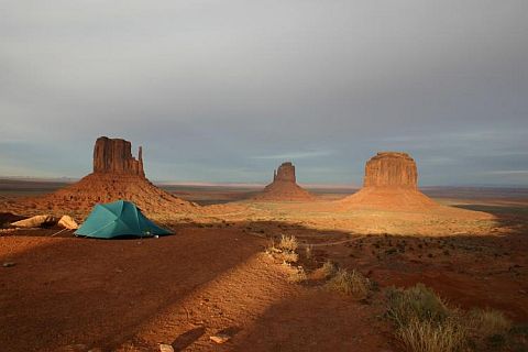
The photo that made me decide "I'm doing this trip!"
The photo that made me say “I’m doing this!”


The route

Tour Coda: To The Coast

September 22nd, 2007

Out: 90.86 mi / 6:53:17 time / 13.2 mph avg. / 36.0 mph max. / 3888 ft. climbing
In: 77.20 mi / 5:22:35 time / 14.3 mph avg. / 35.0 mph max. / 2796 ft. climbing
Stayed at Cape Lookout State Park

Joel (but you can pretend itAfter four days off the bike, during which I focused all of my energy expenditure on finding and eating every scrap of food within a three-mile radius, it was time to get back in the saddle again.

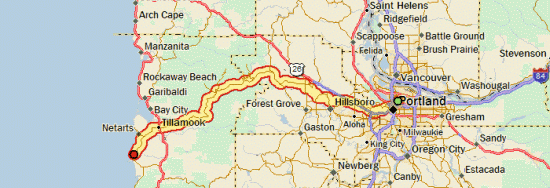
Joel had come home from Arizona on Wednesday night, so we decided that on Friday, we would head out together for the big blue sea, the western edge of the country: the Pacific Ocean. On Thursday I started coming down with the family cold, so I went to bed really early Thursday night and got 10 hours of sleep in an attempt to compensate. That helped a lot, though I still wasn’t 100% in the morning. On the other hand, I was able to lighten my load slightly for this trip, since I didn’t need to take my cooking gear, or most of my clothes. I still carried all five of my bags though, and since I was carrying some of Joel’s stuff as well, I was probably only a few pounds less than normal.

That meant that even with all the rest-and-recovery I had, the 1000-foot climb that starts immediately on the western side of Portland was quite a bear. It was easily the steepest extended climb of the trip, with lots of sections between 12 and 15% grade, plenty of switchbacks, and residents giving us nods of respect and congratulations as we toiled our way upwards at 5 mph. I was finally able to glimpse a backlit Mt. Hood when we neared the top of the hill.

Low Elevation, But A Big ClimbThen of course we gave all the altitude back as we descended and entered the sprawling suburbs and stoplights west of Portland, as well as some flat farm country. We made it to Banks and got an early lunch at Subway, which was my first Subway in a long time. From there we would take the Wilson River Highway up over the Coast Range, and then down to Tillamook. It’s a 1500 foot climb, gentle at first, then steep for the last few miles. By this point, Joel has slowed down a bit, unlike the first climb where I had to work just as hard as I normally do to keep up with him. Still, for a guy who hadn’t been riding much recently and really had no business doing a ride like this, he was doing remarkably well. And for me, it was kind of cool to relax and just dawdle (ok, not really!) my way up a hill for once. On the way up we got a honk and a wave from a blue Subaru going by: Chika and the boys were on their way to meet us at the campground.

After cresting the summit, it was mostly a long downhill through the Tillamook State Forest. We did have to fight a bit of a headwind, particularly once we exited the tree-covered mountains. A quick refueling in Tillamook (moreso for me; Joel was a little skeptical about the amount of calories he would be needing), and then in ten more miles we were at the park.

Chika had found a good site in the enormous campground (177 sites?), shaded, and a mere 50 yards from the beach. We got camp set up, including Joel and Chika’s monstrous 6-person tent (I’ll still be sleeping in my own, thank you!) and got dinner started (we’d borrowed a lot of camping gear from their neighbors, so I’d finally doing some fancy-cooking in camp! Ok, well, at least bratwurst!)

First Sight Of The OceanThen, before the sun set, I had to see the ocean, introduce my bicycle to it, and get a picture. It was pretty awesome to crest the small dune and suddenly see the breakers rolling in. I had carried myself to the edge of the world, or at least somewhere close to it. Just as I rolled the bike into the surf for the traditional “wheel in the water” photo, the ocean made it clear that it’s not something to be taken lightly, and sent a big wave up the beach that went high enough to flood my panniers, and worse, it got Joel’s cell-phone that he’d stowed in the outer pouch of my rain cover. The wave surprised the heck out of everyone else on the beach too, so at least it didn’t make me feel like a total landlubbing dumbass. What made me feel like a total landlubbing dumbass was when I propped the bike up on its kickstand in the sand, and another wave came along, and knocked the whole bike over right into the ocean. Neil Made It Too!Luckily the rain covers did an excellent job of keeping my stuff mostly dry, even though one of them managed to collect a gallon of seawater inside. By that point, I figured the ocean was trying to tell me something, and I did my best to wrestle the bike back up over the sand dune and back to camp.

After a good dinner, we tried another campground luxury, the campfire. Unfortunately, the wood didn’t seem particularly interested in burning, so it wasn’t a very exciting fire, but it was better than nothing. Joel, Chika, Noah, and Ren eventually got settled down in their tent for the night, while I stayed up for a bit having a beer and tending the fire. Then I went to see the ocean again. This time, alone on the beach, without the bike, and with the bright moonlight making the whitecaps shine above the dark water, it was a much more peaceful experience.

During the night I heard Ren wake a couple times, and there was a minor rain shower, but I slept just as well or better than I do most nights. Camping with two kids with a combined age of three certainly isn’t as simple as doing it solo, but overall, it went surprisingly well. No major disasters, and I think everyone had some time where they actually enjoyed it.

Breakfast!Morning was nice and comfortable, and brought more luxury fancy-cooking (pancakes and eggs). We got everything packed up into the car, including most of our bike gear. I took off my two front panniers and half-emptied my rear ones (we’d carried our own camping gear on the way out just in case Chika couldn’t make it for any reason). My bike was still covered in sand and salt everywhere, and I had to let Joel get a head start on the road while I flushed out my right shift lever, which had stopped working because of all the salt that got inside it.

It was weird riding back over roads that I’d already taken, but it was a beautiful day, with tailwinds this time, so I got over it. Lookout TowerWe were smart enough to take breaks a little more frequently this time, and natural/organic-food-eating silly-Portlander Joel finally gave in and recognized the necessity (and pleasure!) of calorie-dense foods that are easy to eat (ie: Little Debbies, or in this case, Dolly Madisons!)

Once we made it back over the Coast Range, we stopped at a small restaurant (with remarkably friendly and flirty waitresses!) for milkshakes, and then caught an incredible, smooth, steady breeze that allowed us to easily float down US 26 at 20 mph for nearly 20 miles. Then, to avoid that final 1000-foot hill back into Portland, we hopped on the light rail in Hillsboro and rode it twelve miles and through the tunnel instead (hey, my ride was done when I reached the ocean, so it’s not cheating!) A final four miles through downtown Portland where Joel whipped me once again over his home turf, and then my ride was truly and completely done.

Chika had had the genius to order in a big ol’ pizza, so I ate about half of that, and then took some of the extra stuff off my bike to make it easier for the bike shop to pack up and ship back to Chicago. I spent the rest of the night packing up a 43 lb. box of the rest of my gear to ship back via UPS, went to sleep, and when I opened my eyes again, it was time for Joel to drive me to the airport. Amazingly, the kids hadn’t woken up yet, so I didn’t get a chance to give them and Chika a proper goodbye, but the fact that they were still sleeping certainly had way more value at that point! It was sure nice to spend a relaxing week with them.

Then, it was into the airplane, towards home, where I would cover a day’s worth of bike riding about every seven minutes. Amazing.

Day 31

Tour Bonus Coverage – By The Numbers

September 19th, 2007

[Editor’s note: added a couple new numbers in response to comments. Let me know if there’s anything more I’m missing!]

20 – Number of days riding without a hot shower the night before. That means I took 9 showers during the trip. Seven were in motels, and two were in campgrounds. I think there were only two other campgrounds that even had showers, so there weren’t a lot of opportunities out there! I skipped those showers either because it was cold and rainy, or because sometimes taking a campground shower can be more disgusting than not taking one. Ten days was by far my longest showerless streak.

7 – Number of different beers sampled. Only one macrobrew, which is quite a good showing, due to the microbrew tradition of the Pacific Northwest, which has bled into Idaho and Colorado.

  • Miller Genuine Draft – Somewhere at a restaurant in South Dakota. Adequate
  • Fat Tire (New Belgium Brewery) – On tap at Applebee’s in Gillette, WY, and in a 22oz. bottle at Montour, ID. Good (the cold, tap one was better!)
  • Unknown craft-brewed Pale Ale – Bought in a single bottle in Canyon Village store and drank in camp. Excellent.
  • Mirror Pond Pale Ale (Deschutes Brewery) – On tap at Bear Bottom Inn, Mackay, ID. Unbelievably excellent.
  • Mt. Borah Brown Ale (Bertram’s Brewery) – On tap at Bear Bottom Inn, Mackay, ID. Good.
  • Black Butte Porter (Deschutes Brewery) – On tap at restaurant in John Day. I’ve bought this one in Chicago before, and it’s an excellent porter, and it was even better locally.
  • Hefewizen (Widmer Brewery) – 22 oz. bottle, cooled in the John Day River. Good, but a Hefeweizen isn’t really meant to be tasted out of the bottle.
  • 177.5 – My weight in pounds when arriving in Portland. That’s about 3 lbs. more than I weighed when I left, which seems to be my usual pattern for these trips. My body fat measurement is lower than normal, so there has apparently been some trading of fat for muscle. I’ve been following my normal post-tour pattern of continuing to eat enormous quantities of food, even though I’m not riding anymore. I’ve been weighing myself frequently just for fun, and my weight has fluctuated up to 6 lbs. in the last couple days. One night I lost 3 lbs. while doing nothing more than sleeping! I guess my body must be spending the energy doing all sorts of internal reconstruction work.

    39 – My resting heart rate in beats-per-minute. That’s the lowest rate I’ve ever measured. My pre-trip rate was around 50 bpm, and “normal” is around 70 bpm. That means my heart has gotten so darn efficient at sending oxygen around to my body that it can take a lot of time off between beats. Perhaps all the high-altitude training had something to do with it, but on the other hand, I never was able to detect any negative effects while riding at high altitudes. Then again, I don’t really have anything to compare to, because I’ve never really been able to try climbing a 9000 foot mountain while staying at sea-level.

    2 – Number of times I used my cell phone (a cheap used Nokia purchased and activated just for this trip). Once was to call ahead to a bike shop in Cody to see if they were open that day (the Sunday before Labor Day) so that I could buy tubes there (they weren’t). The second was to call Chika to let her know I would be arriving a day early.

    2503.34 – Distance that I rode in miles. How convenient that it’s extremely close to the nice round number of 2500 miles! For comparison, my Atlanta trip was 2132 miles in 30 days (27 days of riding, 3 days off), and my North Woods trip was 993 miles in 15 days (14 days of riding, 1 day off).

    83.4 – My daily average distance in miles. Slightly higher than my target goal of 80, but that means I was able to see a little more of the country (like the extra detour in Yellowstone) and still finish in 30 days. The 83.4 average compares to 71.1 for Atlanta and 62.2 for North Woods, but unlike this trip, I took some days off on those. If I ignore days off when computing the averages and count only the days when I rode, the numbers are 83.4 / 79.0 / 66.2. So this was my longest trip any way you measure it.

    10 – Number of 99+ mile days. I never expected that I would put in so many big-mileage days (the Atlanta trip only had four in this range). Most of them weren’t much of a struggle though, and just sort of “happened” naturally, due to good tailwinds, long downhills, or just a lot of time in the day without much reason to stop.

    6 – Number of flat tires. One was due to the valve stem coming out of the tube, so that doesn’t really count, and then I think two of them were caused by the same debris field (tiny bits of wire). Then I had one from a staple, one for an unknown reason, and one from something big and sharp that put a large gash in the tire. Given all the smashed beer bottles that litter the side of the road across America, I’d say that’s a pretty low number of flats. My 700Cx37 Schwalbe Marathon Supreme tires are looking pretty thin in the tread department after 3000+ miles on them, but overall I’d have to say they were well worth the expense. They also did very well on plenty of nasty gravel roads.

    7 – Number of nights I wussed out and stayed in a motel. That means I did 22 nights of camping, which is three more nights than the Atlanta trip, so I guess that’s pretty good. I always say that if I’m lugging all the camping gear across the country, I might as well make good use out of it. The motel nights were pretty concentrated in South Dakota and Wyoming, with two sets of back-to-back motel nights, and once three out of four nights. That means I did one stretch of ten straight nights of camping, which is a new record for me. One interesting related fact is that I stayed in zero private campgrounds. Every place I stayed was a state park, county park, city park, National Forest, National Monument, National Park, or Wildlife Management or Bureau of Land Management site. On the other hand, although I camped for free a couple nights, I did no ‘guerrilla’ camping at non-designated campsites. It’s amazing how helpful a simple table can be when camping, which is one thing that stops me from just camping off the side of the road.

    2000 – A rough estimate of the number of dollars I spent on the trip. In addition to food and lodging, that includes the flight home, and equipment I bought on the road, but not stuff I bought in preparation for the trip. Some people I met would say “hey, it’s cheaper than flying!”, but that’s true only if you look at it in per-day expenses. If I was just to fly to Portland and back and stay for a week, I could do it for a lot less than $2000! But if you look at it as $65/day for 30 days, that’s probably a lot cheaper than most vacations.

    2 – Number of items I lost on the road. That includes my sunglasses, which I lost presumably somewhere in Apple River State Park on my first night out, and my sweatband, which I think I must have dropped when I took a photo of myself at the top of the Bighorn Mountains, at 9066 ft. At least I left the sweatband in a place of honor!

    3 – Number of non-consumable items I bought along the way. Two replacemnt items, which were new sunglasses, and a new sweat device. This one was a Headsweats cap that covered my whole head, which was nice to have in the cooler weather of Idaho. The only problem with it was that the elastic left some pretty goofy-looking creases in my forehead at the end of the day, and it seemed to really accentuate my forehead tanline. The completely new item was a pair of Smartwool socks. It’s the first wool product I’ve bought, and while they’re very nice socks, I don’t think I’m going to turn into a wool freak (especially since it was a $17 pair of socks!) But they made camp a lot more comfortable because I could wear them with my shorts and sandals in the cool evenings and still be comfortable (fashion be damned!)

    0 – Number of things thrown at me out of passing cars. In fact, I can’t even recall a single instance of someone even yelling something at me. Quite amazing for a 2500 mile trip! The most annoying things were dogs in passing cars that would bark right in my ear as they flew past, scaring the bejeesus out of me every time. And if that’s the worst thing to complain about, I think that means it was a pretty nice ride.