Tour Day 30: Warm Springs, OR to Portland, OR

September 16th, 2007

106.00 mi / 7:55:15 time / 13.3 mph avg. / 33.0 mph max. / 5058 ft. climbing
Staying at Joel, Chika, Noah, and Ren’s House

It turned out that the party house was much less annoying during the night than the group at the site next to mine who were up yapping and laughing until 2am. Luckily my earplugs do a pretty good job of filtering that stuff out, so I was able to catch enough sleep between wakings that when I woke for real a 6:30am, I felt fairly fresh.

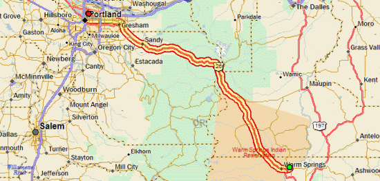
I crawled back out to US 26 on the bad gravel road, and then crossed into the Hot Springs Indian Reservation (I’m probably the only one who finds it funny that the town of “Madras” is the closest city to an Indian Reservation). Surprisingly there was a little strip-mall-ish thing there that said “FREE INTERNET”, so I pulled in to check on things. I had an email from my brother saying that he almost surely was in Arizona, which meant that he wouldn’t be riding out to meet me at Trillium Lake campground as we’d been hoping, to camp one night and then ride in together the next day. That was disappointing, but it left me with a decision: continue as planned and do 50 uphill miles and camp, or just blow through the whole 100+ miles to Portland in one day. My pre-trip planning focused on a 30-day ride, but that was always a very hopeful estimate, with the assumption that days off or other setbacks would actually make it more like 32 or 33 days. Since very early into the trip when I got off course a bit I had been targeting 31 days, but now, could I actually do it in the original 30? I figured I would make that decision once I got to the 50 mile point.

When I blasted through the 1200-foot climb out of the Deschutes River valley like it wasn’t even there, I thought “ok, I’m totally going to do it all in one day”. Especially when I got to the flat section on top and was cruising along at 19-20mph. And then, out of nowhere, the wind came and slammed into me like a brick to the face. It was the strongest wind of the whole trip, and was mostly a crosswind, requiring all the skill and strength I had to keep the bicycle moving in a (relatively) straight line at 9mph. That’s when I thought “ok, I’m doing this in two days, and I’ll be lucky to even make it the 50 miles to Trillium Lake today”.

Crossing The 45th ParallelHowever, after about 15 miles, I exited the open grassland and entered the forest, and the winds almost disappeared. I still had a lot of climbing to do though, all the way back up to 4000 feet. So I still wasn’t sure what I would do. Then, when during a break I semi-consciously ate one of my last two NutriGrain bars that I had been saving for the next morning’s breakfast, I realized that I had gone all in. I would be completing my journey today.

I soon passed right by the turnoff to Trillium Lake, and then stopped at a rest area at Government Camp, where I had a lunch made out of all my remaining foodstuffs. It was from there that I gave Chika a call to let her know that I was coming in. It had taken me nearly seven hours (five of them riding) to cover the first 53 miles of the day; so I told Chika that I would be there at 6pm, which gave me three and a half hours to cover the same distance.

And so I began my final segment of the trip, a 53 mile downhill that would drop me nearly 4000 feet. Though the winds held off, it did begin to rain just after I started, and would never completely stop. But at that I point, I didn’t mind at all. The only sad part was that, due to the clouds, I didn’t actually ever see Mt. Hood. So I guess it’s a good thing that I had the fake-Mt. Hood experience yesterday.

Arrival!For no particular reason at all, I did those final 53 miles without a break (except for stop lights, and even then, I did the first 38 to Gresham without putting a foot on the pavement). I guess I figured I didn’t need to save myself for anything; there would be no riding tomorrow, after all! That meant that I rolled up into the suddenly-familiar driveway at 5:45, comfortably exhausted, to be warmly greeted by Chika, Noah, Ren, and Kai. Just a little 2500 mile bike ride to see my family, right?

But stay tuned, the journal might not be over yet. As a coda, there’s talk of a ride out to the big blue ocean in the coming days. Also I have a wrap-up piece or two that I’m planning on posting. But for now, I think I’ll take a bit of a nap, if you don’t mind.
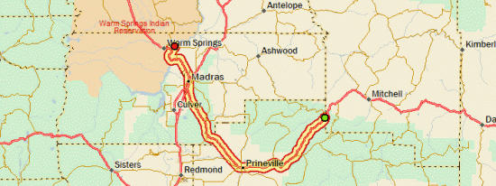
Day 30

Tour Day 29: Prineville, OR to Warm Springs, OR

September 15th, 2007

75.74 mi / 4:57:20 time / 15.2 mph avg. / 32.0 mph max. / 1113 ft. climbing
Staying at Mecca Flat BLM Campground

Largest Roadkill SeenToday would be an easy day, so I started slow in the morning, reading the copy of Outside magazine that was given to me by a fellow traveler in Stanley, and then doing a short hike through the pines. There had actually been a tiny bit of drizzle in the night, which sent me scrambling out of the tent to cover my bike seat and grab my shoes, but it stopped before anything actually got wet.

The ride started with some LSD (Long Steady Downhill), which got me quickly into Prineville (pop. 9990, big city!) Did library’n’lunch there, where I suddenly discovered a campground just off US 26 near Warm Springs. I had been planning on a state park a good way off US 26 that would have given me a 60 mile day, but I quickly scrapped that and went for a somewhat longer day in trade for less mileage over two days.

Mt. Jefferson (not Mt. Hood!)Halfway between Prineville and Madras, as I came over a hill, I saw a small mountain and thought, “hmm, that mountain has that low, wide, volcanic slope to it, almost like Mt. Hood. I must be getting close to those Cascades.” Then I looked a little to the left, and lurking behind it, a good eight times larger, “Holy shit, that’s Mt. Hood!” It was difficult to see through the haze and distance, but seeing those bright glaciers shining through was quite an overwhelming feeling. I think I rode the next three miles with a huge goofy-ass grin on my face.

Only thing is, it turns out that it wasn’t Mt. Hood. It was Mt. Jefferson. D’oh! I discovered that fact as I passed to the north of it without ending up in the Columbia River. Well they look pretty darn similar, how am I supposed to know? It’ll be interesting to see if I feel the same way when I see the real Mt. Hood tomorrow.

Mecca Flat CampgroundMadras is big enough for a Safeway, so I did my final good grocery stock-up, including a big sub and a beer that I would take to camp for dinner. The last five miles of the day (except for the two miles of gravel to camp) were down into the deep Deschutes River gorge, sending me to less than 1500 feet! I’ve shrunken down to 5-foot-8 here because the tremendous air pressure is squeezing me down! So I spent last night at the very top of a mountain, and tonight at the very bottom of one.

The campground is also the complete opposite of last night’s: a field of burning dust being blown around by a hellish wind, and right next door is some kind of private party house with lots of barking dogs, so we’ll see how the night goes!

Day 29

Tour Bonus Coverage

September 14th, 2007

An Ode To The Commode

Most of the campgrounds that I’ve been staying at lately have had only vault/pit toilets, which is basically a glorified hole in the ground that you poop in, with no running water involved. The interesting thing is that every vault toilet I’ve used from the Black Hills on west has been of a very similar design. It doesn’t matter if the campground is National Forest, National Park, Wildlife Management, or Bureau of Land Management, they must all use the same toilet designer.

img_0788.JPGWhat makes that very exciting is that the toilet designer did an excellent job. In the Midwest and East, a pit toilet often means a ramshackle wooden structure filled with flies that smells really bad. In the North Woods I even had one that was just a wooden box with a hole in the top of it, right out in plain view!

img_0790.JPGIn contrast, these are concrete-walled structures with solid, locking steel doors. They’re painted white inside for visibility, have a lot of room (they’re usually ADA-compliant), and they all even have a nice hook on which to hang your jacket. The toilet seat is comfortable, and the lids are used as the signs direct. They have no odor at all, except for perhaps the nice smell of an air-freshener placed inside. The last couple I’ve used have even been dual-units, with a central hall between them that shines electric light through internal windows. They have a curious built-in sign that reads “PLEASE… DO NOT put trash in toilets. It is extremely difficult to remove. THANK YOU”. “Difficult” is probably not the exact word I would have used to describe it, but hey, if it keeps people from throwing trash in there, then that’s super. As perfectly as everything else is designed, I’m sure they researched that sign very carefully to determine the most effective deterrent.

On the last couple of windy days, I’ve noticed one unexpected surprise of the vault toilet: a good breeze will blow into the external vent stack and give your bottom some nice air-conditioning from below. For free!

An Ode To The Commode

O, my wonderful Western toilet
Not even the most fearsome log can spoil it
Some call you pit, some call you vault
By any name, you are a can without fault

Smells sweet
Cool seat
Made of concrete

We all must heed nature’s call
So this is a stall that can handle it all
And when you’re in a rush
You need not remember to flush

[Editor’s Note: The main text was written several days ago, but the poem was only composed when inspiration struck, which was yesterday, during the 2000-foot climb up to Ochoco Divide]

Tour Day 28: John Day, OR to Prineville, OR

September 14th, 2007

83.58 mi / 6:44:50 time / 12.3 mph avg. / 35.0 mph max. / 4568 ft. climbing
Staying at Ochoco Divide National Forest Campground

To show the world (by which I mean, nobody) that even a day like yesterday can’t wear me out at this point, I took advantage of the slight downhill and slight tailwind and blasted through the first 32 miles to Dayville in well under two hours, in another No-Stop morning. I fueled up there with a hearty 2nd-breakfast, since I would be needing the energy for the next 50 miles. Dayville’s gas station is a Little Debbie shop (Texas Cinnamon Roll, Cherry Pie, and Fudge Round), and my milk carton actually said “Thank you for buying local East Oregon milk”, so yay!

Picture GorgeThe descent ended at Picture Gorge, part of the John Day Fossil Beds National Monument (this John Day fellow is rather popular around here). While most of eastern Oregon has been quite scenic compared to a place like Illinois, with hills and mountains all over the place, this was the first “wow” area; it’s quite a badass canyon, and that’s coming from a guy who has been through more than a few. Halfway through the canyon, after following the John Day River downstream all morning, I made a left turn at a three-way river intersection and began following a tributary upstream.

The Oregon Mountain Climbing Efficiency Board held an emergency meeting last night, and decided that days like yesterday’s four 1000-foot climb day didn’t make any sense, so for today they compressed it into just two climbs. The tradeoff is that now they were both 2000-foot climbs. The first one was long, at 25 miles, but then of course not very steep for much of the way. It’s interesting to watch the vegetation change with the altitude on these climbs, and the last couple days my friend the fragrant juniper has even returned. Mitchell, ORThey were repaving a long section of the road, but the one-way area didn’t begin until right at the pass, so I was able to ride through it taking advantage of the downhill.

Lunch was at a (I mean, “the”) cafe in Mitchell, another in a long string of incredibly small towns, and then there as a bit more downhill to go until I started climb #2. Ochoco Divide National Forest Campsite This time, the one-way section started at the uphill, so they had to put me in the truck for a bit. But it was less then four miles, and only about 300 feet up, I so don’t feel like I was cheating too much. This time when the pilot truck driver announced my ride over the CB, a response came back, “I think I’d have to be retarded to do something like that!”

From there, it was just 2000 more feet of climbing, this time at 5-6%, until I got to Ochoco Divide Campground at the very top of the pass. There’s a bicycle section here, and the web says it’s $4, but the sign says it’s $12 just like everywhere else, so I just took a normal site so I could have some flat ground to pitch my tent. The campground is filled with some pretty enormous 200+ year old pine trees, which makes it a pretty cool spot.

Day 28

Tour Day 27: Vale, OR to John Day, OR

September 13th, 2007

113.86 mi / 8:36:32 time / 13.2 mph avg. / 39.5 mph max. / 5863 ft. climbing
Staying at Dreamers Lodge Motel

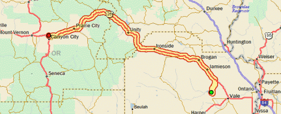
Yesterday at the grocery store in Vale I talked to a little old lady (her words!) riding her Schwinn who was trying to discourage me from camping at Bully Creek, because it meant I’d have to come all the way back east to Vale to get back on US 26. Apparently she’s just too much of a wuss to handle the 8 miles of gravel road that I ended up taking north to the highway. C’mon, grandma! Ok, so “gravel” is used a bit loosely out here; there were quite a few sections piled with 6-inch round river rocks, which I somehow managed to ride over. And then some sections of sand too, which I didn’t. But hey, it’s all fun as long as no one pops a tire (and I didn’t).

So I was all satisfied with myself for surviving on my own planning skills, until I got to Brogan, which was a destination she had suggested (“you’ll have the wind blowing you that way”) and saw that they had a not-bad-looking RV park/campground with showers and laundry for $10. D’oh. But I have hard time trusting people out here, because most of the time I’ve done so much planning that I know more than they do. Case in point, there were a couple of good ol’ boys sitting outside the gas station in Brogan, and GOB #1 says “well, you got less’n 300 miles to go now!” GOB #2 corrects him, saying it’s more like 400 (and he’s closer to the truth). But then GOB #2 says “well once you’re past Dixie, it’s all downhill”. “Oh yeah? Where’s that?” “mmm, about 40 miles”. Well, it’s more like 70, but see, I already knew that.

Eastern OregonSo just after Brogan, I had to climb a 1300-foot hill, which began what a clerk in New Plymouth referred to as “The Passes”. I didn’t really know what that meant then, but now I’m pretty sure this is what she was talking about: four ~1000 foot climbs, some with descents following. Brogan Hill at 3941 ft., Eldorado at 4623, Blue Mt. at 5109, and Dixie at 5277. All that adds up to a day with nearly as much climbing as my day over the Bighorns, and a lot more distance covered. But it also makes for an interesting day with no time for boredom at all. And GOB #2 was right, once I crossed Dixie at 91 miles, the next 22 were all downhill.

After the Brogan Hill, I decided to pump up my tires, and then realized I should have done that days ago, because suddenly I was flying. But then 10 miles down the road I got a flat (from a staple), which maybe wouldn’t have gone through the tire if it was under less pressure. So does it all even out? Maybe as far as time goes, but I guess my energy expenditure is still less.

Oregon Pass #3At Austin Junction (where I had a great ice cream cone), I met my first non-Yellowstone touring cyclist, going the other way. He was originally from Wilmette, and had this weird Extenda-Bike thing that stuck his wheel way out the back so he could mount two really long rear panniers, sort of a pannier/trailer hybrid. Austin Junction is also the point where my pre-planned route shows me getting off US 26, but a couple days ago I made the decision to just take 26 the whole way. Even though it looks less direct, it’s only about 2% farther, with a lot less climbing, and I figured probably a few more people and services (as it is, US 26 is easily the least-traveled US highway I’ve been on).

Coming Down From Dixie PassThe downhill stretch continues past John Day, so I could have easily made it to the state park eight miles down the road (both in terms of daylight and energy), so it was a tough decision whether to continue on or not, especially since they have $4 hiker/biker campsites there. For some reason I decided to just go with the motel, I guess because I realized I’m the only one who cares about the “Camped The Last Two Weeks Straight Without A Motel” record.

Turns out it was a good decision, because the town of John Day loves me. First, the girl at reception told me about 18 times “If you need anything at all, just come by and let me know”. Then as I was walking to my room, I talked with a guy who has ridden all around Oregon and Washington, and he gave me some route advice. Then as I made my way to my room and was opening my first-floor door, the motorcyclist who had been checking in just before me said, “you must be better-looking than me; she told me they didn’t have any first-floor rooms left!” Finally, my favorite: just as I was closing my door, another guy who I’d just briefly spoken with at reception popped by and said “hey, I don’t know if you partake, but if you want to smoke some pot later on, you’re welcome to join us!” I thanked him, but politely declined, and instead went to dinner with the cyclist guy and his friend, who were generous enough to treat me both to a meal and some good cycling conversation. Both have broken the 100,000 lifetime-miles barrier (which is one of my long-term goals) and are still riding, so that was inspiring. Now I’ll go to sleep, and see if I wake up smothered in a pile of money and hookers.

Day 27

Tour Day 26: Montour, ID to Vale, OR

September 12th, 2007

71.56 mi / 4:37:42 time / 15.4 mph avg. / 27.5 mph max. / 1285 ft. climbing
Staying at Bully Creek Reservoir County Campground

House On A Hill, Near Montour, IDIt was nice to not have to worry about freezing to death overnight, and the morning was a full 20 degrees warmer than the previous morning. I headed out of the Montour Reclamation Area through the ominous Black Canyon, and once I was through the canyon, I was suddenly back in Iowa! Perfectly flat, with straight roads laid out on a 1-mile grid, cornfields, and even a herd of black-and-white Holstein dairy cows, which I don’t think I even saw in Iowa. It seemed odd that a whole lot of places I passed were watering their lawns; they must have some kind of “use it or lose it” policy for irrigation water, so everyone decides to use it.

Crossing Into OregonSince it was flat and there was no wind, I was making really good time, especially since I did the 30+ miles to New Plymouth without even stopping for a break. Then I crossed the Snake River and entered Oregon, my final state to cross. I was immediately greeted by a cool and unexpected surprise: a bike lane! But then a minute later, that was balanced out by an uncool greeting: billboards advertising the horrors of meth addiction (I guess I’ll be locking up the bike more often!)

Ontario felt like the biggest city I’ve been in since at least Gillette, WY, and maybe even Rapid City, SD. Certainly the first traffic lights I’ve seen in over a week. But apparently not big enough for the library to open before 2pm on a Wednesday, so I sat outside with another guy and used their WiFi from there. Due to the time I was making, I was toying with the idea of putting in another 100+ mile day, but instead I decided to use the extra time to do some much-needed laundry. My clothes didn’t really stink too bad (except for my shoes, which might be forever damaged by those first days of wetness), but they were all crusty and caked with salt. Conveniently, I could also reach an open WiFi hotspot from the laundromat (I don’t think it was theirs), so I was able to be pretty productive.

Then I did a late lunch at McDonald’s, and cruised the next 15 miles along US 20/26 to Vale. Among the items I got at the grocery store there was a loaf of Goldminer California Sourdough Roasted Garlic Bread. I figured I’m only one state away from California now, so it’s appropriate. Then in camp I read the label that says “Maple Leaf Bakery, Inc., Des Plaines, IL”. I guess I’m not doing a very good job of eating locally! (and I did finish the whole 780 calorie loaf tonight, along with a can of Chili-Mac, a can of Noodle Soup, a Nutty Bar, a Pepsi, and a Toblerone).

But the most exciting event of the day was….a shower! The first one I’ve had since Cody, WY, 10 days ago. It took three rounds of shampoo on my hair before I could even get a lather to form. So combine that with the laundry, and I’m a clean machine, ready for the final push to the end!

Day 26

Tour Day 25: Stanley, ID to Montour, ID

September 11th, 2007

[Editor’s note: ok, ok, new pictures!]

117.18 mi / 7:52:13 time / 14.8 mph avg. / 35.5 mph max. / 3291 ft. climbing
Staying at Montour Campground (Bureau of Reclamation)

Stanley Lake @ 24 deg. FTwo pairs of socks (short cycling socks and long warm Smartwool), four bottoms (cycling underwear, full-length tights, Windstopper pants, baggy shorts), three tops (long-sleeve zip-top, t-shirt, jacket), two hats (a face-covering balaclava and sweatband hat), and full-length gloves. That’s what it takes to survive a night where the temperature dips down to 24 degrees (the lowest reading I saw on my thermometer was 27, but that was after the sun was up, so I bet it did get down to the predicted 24). And with all that, I actually slept pretty well. Even better, getting up in the morning is pretty easy, since I already have all my clothes on!

Stanley Lake, IdahoAnd what a sight to awaken to! The haze was gone from the sky, so the rising sun was lighting the sawtooth peaks quite dramatically, as tendrils of mist were rising off of calm Stanley Lake. Hopefully the camera saw it as well as my eyes did.

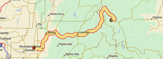
I was out of camp a little after 8 AM, and I had one last push up a hill for the first 20 miles, and then I would go down, down, down. The Wind Gods had taken another day off, so what little wind I felt was changing direction aimlessly and not affecting much. I crested the hill at around 7000 ft., and then caught up with the South Fork of the Payette River, which I would follow down the mountain. The area I was riding through truly National Forest land. National Forest SignageIn many National Forest areas, there are lots of private lands within the boundaries, so it hardly feels different than any other road. But I rode 46 miles before coming across the first private parcels (so it’s a good thing I had plenty of breakfast to get me that far!) There are also about a million campgrounds and trails; I could spend weeks exploring the area.

I got lunch in barely-a-town Lowman, from the store which is set up inside of a trailer. After that, my “riding along a river is good riding” rule was violated, as I climbed a huge hill that eventually took me 500 feet above the river, even though it was still right next to me. I guess the river canyon is just too narrow to fit a road down there too, so the road has to ride up the mountainside. Sawtooth National Recreation AreaThe up and down pattern continued, but there were more downs than ups, and climbing hills actually makes the riding seem to go by faster anyway, since I’m constantly changing my approach and doing something different. I’d heard yesterday that they were closing the road between Lowman and Banks from 5-9 pm each night for fire-related activities. So I was a little concerned about that (and more concerned about the reported smokiness and my ability to breathe), but I didn’t see any evidence of impending closure, or smoke. I saw a helicopter carrying a bucket fly by, but that was the only fire-suppression activity I noticed.

When I headed south out of Banks, I discovered a new type of rumble-strip, this one designed to irritate drivers instead of me! It was right down the center double-yellow line in the road, I guess to really discourage passing in no-passing areas. Luckily, they seemed to annoy drivers less than they annoy me, so the drivers generally had no problem rumbling over them to go around me and pass.

Judging by all the rafting outfitters and the size of the parking lots and the signs warning about congestion near the put-ins and take-outs, this Payette River must be one heck of a popular place for whitewater rafting. I didn’t actually see anyone on the river today though.

117 Miles And A BeerWhen I got to Horseshoe Bend, I went looking for the Subway mentioned on the town’s website, but it was nowhere to be found. Since I didn’t feel like dinner at a steak place, I had to settle for the grocery store and dinner in camp. I’d already gone too far south looking for the Subway, so I decided to take the direct, gravel-road route to the campground and save myself a few miles and two river crossings. It turns out that it was quite an adventure, with a lot of unnecessary 8% grades to climb (again, I’m still following the river). But I was feeling unusually strong from mile 80 on until the end, so it was no big deal. Was it the Cherry Garcia bar I got in Garden Valley that fueled me? Or was it spending weeks riding at well over 5000 ft, so now I’m getting oxygen-overload down at 2500 ft.? My only concern was that I wanted to cover the 8 miles before my 22oz. Fat Tire beer got too warm! I can’t figure out why that beer is so widely available, but since it’s better than most, I won’t complain. And how could a beer get too warm after a 24 degree morning? Well, the temperature had probably increased at least 60 degrees throughout the ride, which is one hell of a swing.

So with that, I say goodbye to the Rocky Mountains (though not mountains in general). I haven’t been this close to sea-level since before the Black Hills. Thanks guys, you treated me fairly, and gave me more than I could have imagined. I hope we meet again sometime!

day25.gif

Tour Bonus Coverage

September 10th, 2007

Since I had a short day and lots of extra time yesterday (and today), I was able to write up responses to a bunch of comments and emails. So here they are, in one big pile!

“Joel asked: Where were those heads of Reagan and Bush?” That was on the way to Mount Rushmore. I didn’t get closer to investigate, but I’m guessing it was some sort of proposal for Mount Rushmore Part II? Or the anti-Mount Rushmore? To be fair, hiding behind Reagan was also a bust of Kennedy, but when I approached it I saw it just like the photo (and adding Kennedy almost makes it weirder, if that’s possible!)

Jean asked “What are the bugs like in SD? Were they bad in Iowa? I would think with all the rain you had at the beginning they must have been awful. Hope you have lots of bug spray with you.” I think there might have been two nights (probably in Iowa) where I noticed mosquitos, and only one where I actually used insect repellant. Beyond that, there have been so few bugs that I haven’t even been concerned with keeping my tent door closed (which is normally a priority in mosquito country). In Wyoming there are areas with tons of grasshoppers sproinging all over the place, and atop the Bighorns I saw these enormous freaky black Alien-like things (getting eaten by grasshoppers), but nothing that actively bothers me. Oh yeah, there are also these weird flying things that make this really loud clacking noise as they’re randomly darting around. That was mostly a Wyoming thing, but there are still a few in Idaho.

Dana said “don’t play w/the racoons at the campsites. They are mean – seriously.”
Surprisingly, I haven’t seen or heard any campground raccoons in the whole trip. Plenty of dead ones on the side of the road, so I know they live out here (although lately I think I’ve been seeing more dead porcupines than dead raccoons). Maybe the campgrounds I’ve been staying at are just too well-maintained to attract raccoons. I guess if you’re building your trash receptacles to keep bears out of them, that also keeps raccoons out by default.


Dana said “I suggest the Star Crunch and the Peanut Butter Twix-like one. They are my faves”.
On your recommendation, I tried the Star Crunch way back in SD (I think their website even says it’s their most popular or something). Sorry to say, it didn’t work for me. It has some kind of caramel-y goo inside that rubs me the wrong way. On the other hand, the Nutty Bar (which I assume is the Peanut Butter Twix-like one) is superb. I’m not really sure why I didn’t eat them before now. It might be because my best friend from grade school would have them at his house regularly, so it didn’t have the exotic, gourmet allure to me that all other Little Debbie products have. But boy, was I missing out!

Dana said “Ok, stupid question from the e-journal challenged, here: Once I post my entry by clicking

Tour Day 24: Clayton, ID to Stanley, ID

September 10th, 2007

49.96 mi / 4:11:13 time / 11.9 mph avg. / 20.5 mph max. / 1909 ft. climbing
Staying at Stanley Lake Inlet National Forest Campground

Milky WayThere was some great star-gazing last night, where the bright band of the Milky Way inevitably draws your eyes upward, even on a simple walk to the toilet. In the morning, I stayed in the tent a little longer than usual, both because I knew I had a short day coming, and because I wanted the sun to rise over the mountains to warm things up a little bit.

When I did roll out, I happened to check my front tire for some reason, and found it completely flat. I have no idea why, since the tube seemed fine when I took it out. But since it was the front tire and I hadn’t packed up the bike yet, it was a simple tube change. Much better when these things happen in camp than when on the road!

Sawtooth National Recreation AreaThe morning presented itself with high-pressure deep blue skies and very little wind, a perfect day for cycling in a great environment. I continued winding up the Salmon River Valley. As I gained elevation, the evergreen trees began coming down the mountainsides and replacing the sagebrush. At some point, the National Forest guys came along and said to the Bureau of Land Management guys “see, there are trees now, we can take it from here.”

Since it was a short day, I stopped at every little roadside marker and display, two of which were very cool. The first was a salmon spawning ground, and quite serendipitously, the salmon were actually spawning there (in the Salmon River, no less!) Salmon Spawning, Salmon River A 900-mile trip upriver, to breed and die. While I’m also traveling upriver, I’ll try to avoid the following their example too far. I guess if I had a canoe, that means I could also put in right there and float down the Salmon to the Snake to the Columbia and all the way to Portland. The other stop was at a hot spring coming out of the mountainside and flowed into the river. This was nice because, unlike all the fragile areas at Yellowstone, I could actually walk over to the spring, put my hand in it, and say “damn, they don’t call it a hot spring for nothing!”

I ate no Little Debbie products today, because the place I stopped at was a Hostess shop. Most places are either Hostess or Little Debbie; only very rarely will a place sell both, and in those cases, the racks are usually well separated. Hostess is good, but it’s not better than Little Debbie, and it’s way more expensive. Anyway, I got an Apple Pie, and then a Big Texas Cinnamon Roll from an independent bakery. The Roll actually had an emblem on the package declaring that it was 2007 Snack Cake of the year or something like that, so I had to get it. Turns out it’s from the Clover Hill Bakery, which is located where? That’s right, Chicago, Illinois.

McGown Peak, Sawtooth MountainsStanley is another town that sits at a flat river confluence, surrounded by high mountains. These are the Sawtooths, and they are aptly named, for they’re the most jagged and pointy mountains I’ve seen so far. I was expecting Stanley to be more resort-like, since it’s “The Gateway to the Sawtooth Wilderness”, but I guess maybe wilderness travelers are looking for wilderness, not resorts. The town center is actually on gravel roads. I got my third identical roast-beef deli sandwich in as many days, and then spent a long time in the library (which doubles as the librarian’s house, I think) figuring out the last week of the trip.

Then it was nine more miles up to the campground at Stanley Lake, where I got a lakeside campsite with an amazing view of the mountains. Unfortunately the air is a bit hazy (smoky?) so it doesn’t make for the best pictures.

Day 24

Tour Day 23: Mackay, ID to Clayton, ID

September 9th, 2007

66.02 mi / 5:42:51 time / 11.5 mph avg. / 25.5 mph max. / 2292 ft. climbing
Staying at East Fork BLM Campground

Lost River RangeI was wrong about the Wind Gods yesterday. They weren’t repaying their debts, they were loaning me free wind, and today, they wanted to be paid back. The first section of the day was admittedly a 1000 foot climb over a pass, but I had 25 miles to do it in, so that doesn’t sound too bad. But it took me three hours of riding, at an average speed of 8.5 mph. Oh boy was it brutal. Even when I was headed straight toward a mountain to the north of me, the wind was still blowing fiercely out of the north. Where was it coming from? Straight out of the mountain?

Borah Peak, Highest Point In IdahoOn the way I passed Mt. Borah, the highest point in Idaho, although I’m not exactly sure which one it was (there are a lot of 12,000+ ft. peaks in the area). I’m guessing it was the one I could see some trickles of ice on. It’s interesting that I’ve come within a few miles of the highest points in the states of Illinois, Iowa, South Dakota, and Idaho. I don’t really count Montana, and I’ll be going pretty close to Mt. Hood, which must be the highest point in Oregon. That just leaves Wyoming, which must have the Tetons for the high point. Maybe I should have went there instead of spending an extra day in Yellowstone!

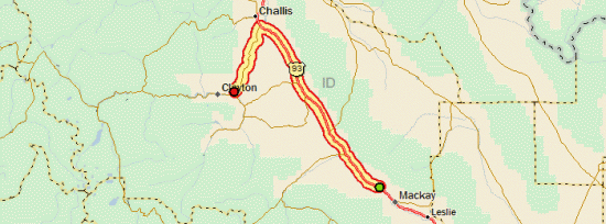
Once I crested that stupid pass, then it was a long downhill towards Challis. The wind must have lightened a little, because I didn’t have to push that hard on the downhill to maintain a decent speed. At one point I went through the surprising Grand View Canyon for a mile or two, which is a really narrow, straight-walled rocky canyon. I guess a river must have run through it at one point, but now there’s just a road. And a lot of graffiti on the rocks, which is weird, because it’s kind of in the middle of nowhere.

Near Challis, IdahoOnce through the canyon, I could see Challis from miles and miles away. It sits in a big flat valley, completely surrounded by a ring of mountains. Luckily the gas station at the intersection of US 93 and ID 75 (where I would be turning from northwest to southwest) had deli sandwiches (another roast beef that was almost identical to the one in Arco!) and enough groceries so I didn’t have to do the couple extra miles out of my way north to town.

Salmon River ValleyThen I turned southwest and headed up the Salmon River. That meant climbing again, but now I had the wind with me, so it was pretty easy. The entrance to the valley was the narrowest, steepest-walled river valley that I’ve been in (excepting the Grand Canyon of the Yellowstone, which doesn’t actually have a road running through the bottom). There was a sign telling me to watch out for bighorn sheep on the road, but unfortunately I didn’t see any. Eventually the valley widened, and, as usual, the farmers and ranchers took advantage of every bit of flat ground to create unnatural plots of green in the near-desert conditions.

Hmm, have you noticed that I picked up Backpacker Magazine’s Global Warming Issue yesterday? It basically goes on and on about how all our National Parks are doomed. All the glaciers are going to disappear, and the forests are going to get all crappy. I saw a lot of evidence of mountain pine beetle leaving huge stands of pine trees gray and dead in both the Bighorns and Yellowstone…I don’t know if those particular instances were global-warming fueled (the beetle is infesting much broader areas as temperatures increase), but they sure didn’t look pretty. So if all the stuff I’m writing about and taking pictures of sounds interesting to you, go see it now, before it’s gone!

East Fork BLM CampgroundIt seems like just about everyone I’ve talked to in the last few days, including the campground host tonight, has said “Portland? That’s a long way to go!” when I tell them that I’m riding from Chicago to Portland. They seem to completely miss the fact that Chicago to Idaho is over twice as far. I can only guess that it’s because Portland is close enough so they have a fair idea how far away it is, whereas Chicago is some nebulous area in who-the-hell-knows-where.

Day 23